Featured Project
Salmon Habitat Assessment on the Grande Ronde River
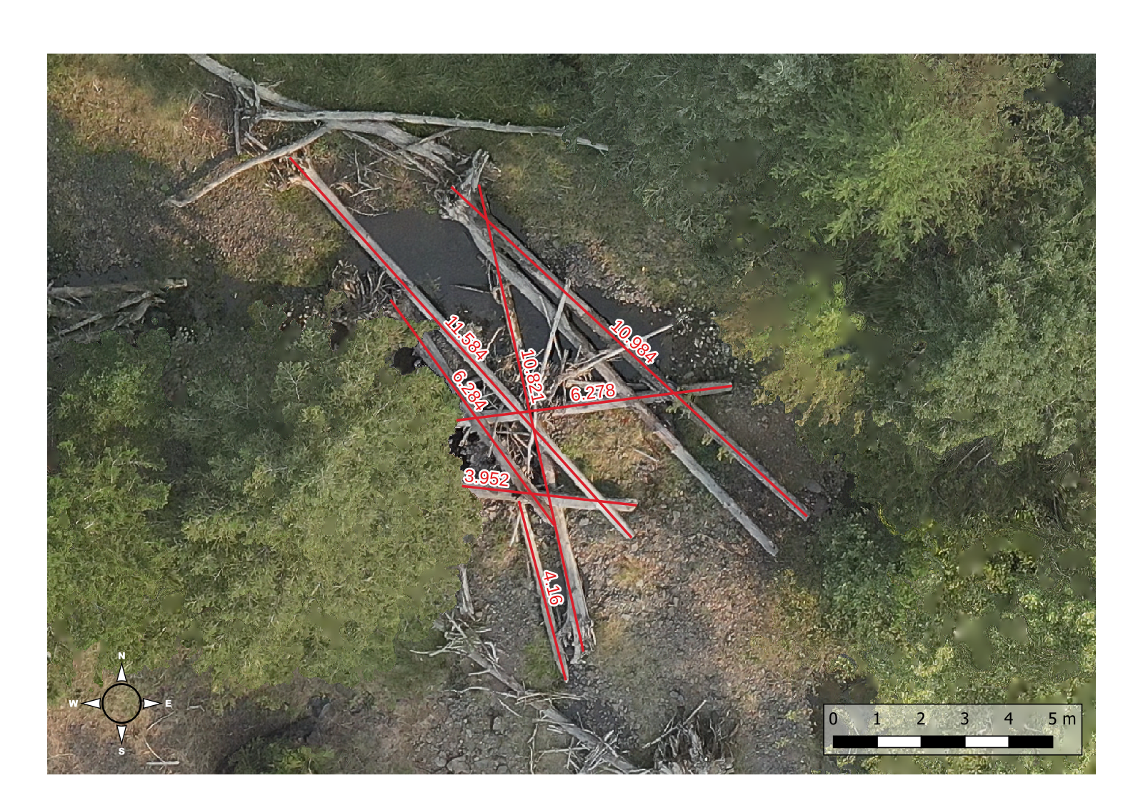
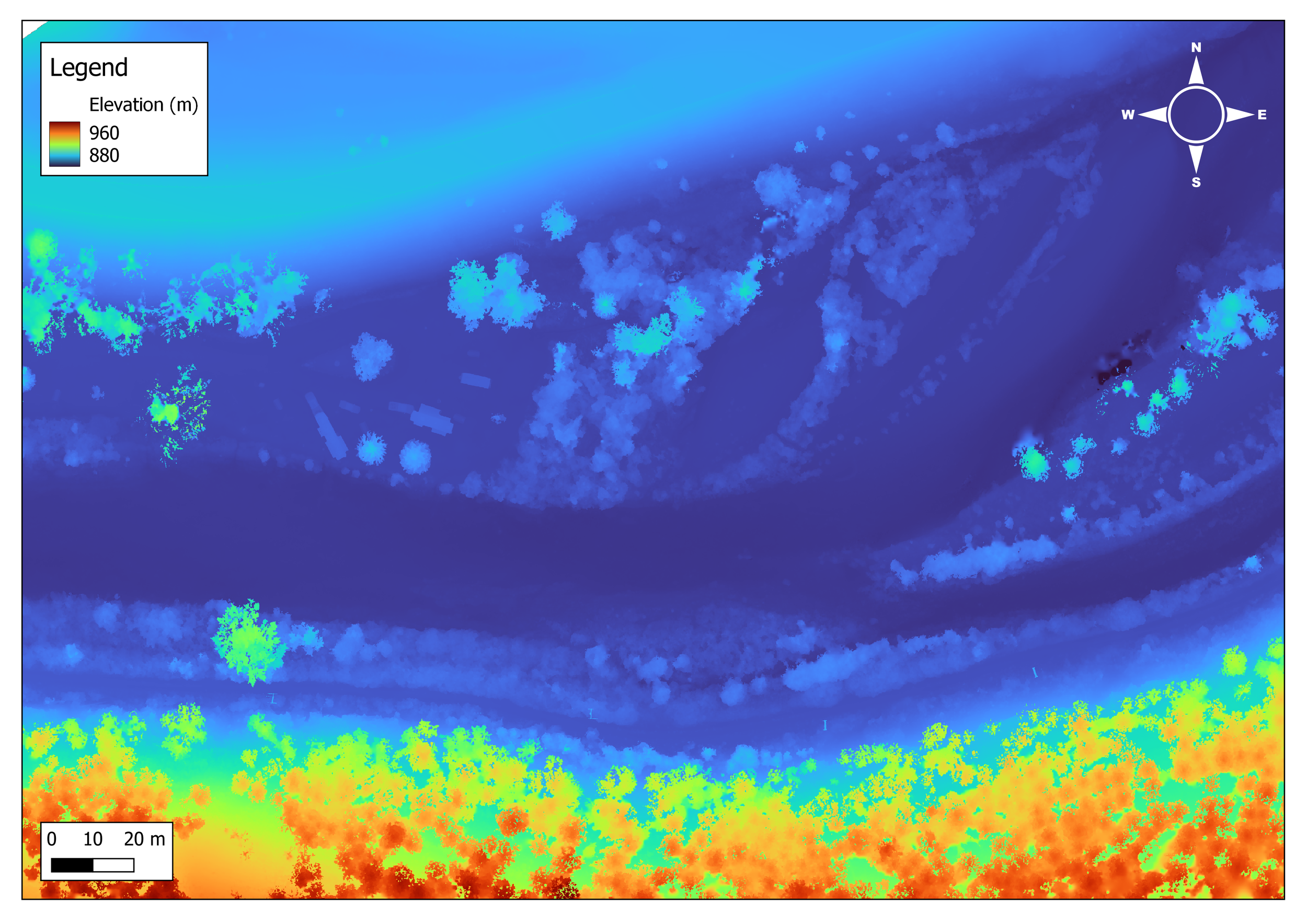
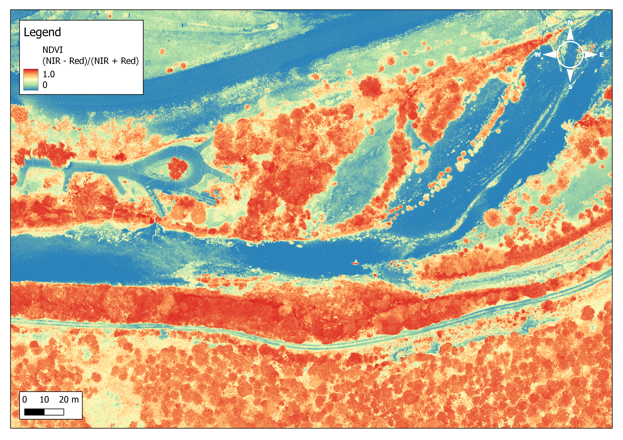
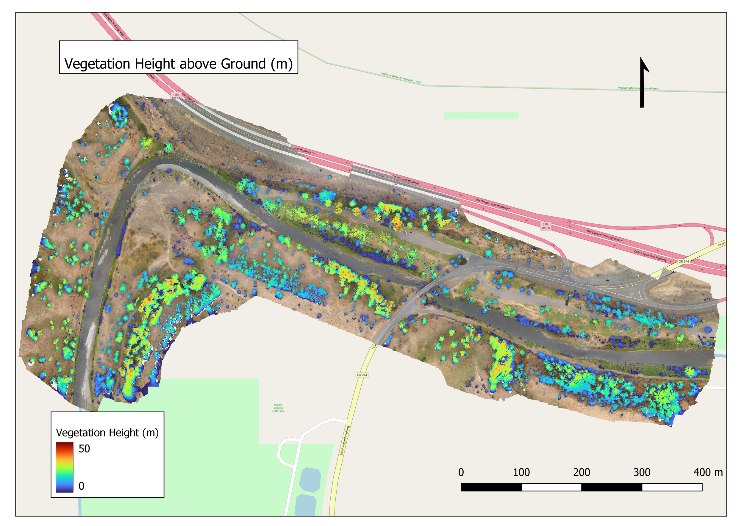
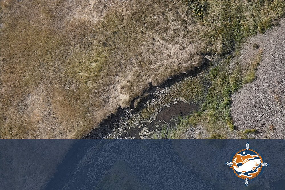
ForeSight contributed aerial data collection and post-processing in support of CRITFC’s Tributary Habitat Assessment Protocol. A dual-payload medium-lift quadcopter was used to collect high-resolution RGB and simultaneous 6-band multispectral data, using PPK for geolocation correction. ForeSight delivered orthomosaics, digital terrain models (DTMs), digital surface models (DSMs), NDVI layers, and canopy height models (CHM).
Results
ForeSight Drones partnered with CRITFC biologists to provide data for investigating fish-habitat relationships at multiple spatial scales and in locations that are very challenging to survey with traditional ground-based methods. Drone-based data produced spatially accurate maps of complex channels, enabled tracking habitat changes over time, and computing accurate measures of habitat metrics (e.g. river complexity, side channel ratio, riparian tree cover, riparian tree height, large wood area percentage, overhanging vegetation cover, etc.).
Aerial Mapping,
Aerial Topo Mapping,
Multispectral Mapping
Services
Client
September 2022
Project Date
![Aerial map of large woody debris (LWD) in a river side channel with overlaid measurements from GIS.](https://images.squarespace-cdn.com/content/v1/653675f57f96e167c1b44371/d3bb0138-a1f9-4adb-ba57-70887ba618e3/LWD_sample_v2.png)
![DJI M300 UAV drone with dual payload P1 RGB and Micasense Altum multispectral sensor with the multispectral calibration panel.](https://images.squarespace-cdn.com/content/v1/653675f57f96e167c1b44371/c6d5b0be-dc63-4227-882e-347d1da10498/PXL_20220831_193637677.jpg)
![DJI M300 drone uav on landing pad ready for takeoff along the Grande Ronde River of NE Oregon.](https://images.squarespace-cdn.com/content/v1/653675f57f96e167c1b44371/15c22f64-a6b8-43aa-9f6b-74d382bb0ca6/PXL_20220911_160047648.jpg)
![Man carrying large case with drone UAV and surveying equipment into a remote river canyon.](https://images.squarespace-cdn.com/content/v1/653675f57f96e167c1b44371/43fe6098-2b70-4700-94f1-5c7e745ed00b/PXL_20220914_162018005+%281%29.jpg)
![Drone operator flying a DJI M300 for riparian habitat mapping.](https://images.squarespace-cdn.com/content/v1/653675f57f96e167c1b44371/06816f0f-7698-417a-ac8e-4a3cd52717f8/PXL_20220916_182451304.jpg)
![Drone operator placing a ground control point (GCP) in a riparian zone preparing for an aerial mapping mission.](https://images.squarespace-cdn.com/content/v1/653675f57f96e167c1b44371/c769da5c-9797-4f42-a586-88e6890b3023/PXL_20220911_223354415.jpg)
![Sample orthomosaic of Grande Ronde River in Oregon.](https://images.squarespace-cdn.com/content/v1/653675f57f96e167c1b44371/86e62643-b527-4124-8f35-8bea3aa7ed2b/area1_sample_ORTHOv2.png)
![Sample digital elevation model (DEM) of riparian zone for salmon habitat mapping of the Grande Ronde River of Oregon.](https://images.squarespace-cdn.com/content/v1/653675f57f96e167c1b44371/4a2f104b-16b6-4d82-92a6-4a75fcf2bc28/area1_sample_DEM.png)
![Sample NDVI map of riparian zone for salmon habitat assessment mapping along Grande Ronde River in northeast Oregon.](https://images.squarespace-cdn.com/content/v1/653675f57f96e167c1b44371/ab3df2c0-d81a-4cc4-b37f-2a497b106bb1/area1_sample_NDVI.png)
Interactive Experience
"Nick Wagner and his crew at ForeSight Drone Services were thoughtful, organized and efficient throughout the whole process. They were able to adapt to changing study plans on the fly in response to unforeseen changes in landowner permissions.
We would happily work with them again."
Casey Justice, Fishery Biologist, CRITFC
FEATURED CASE STUDY